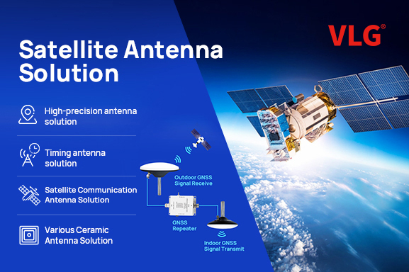
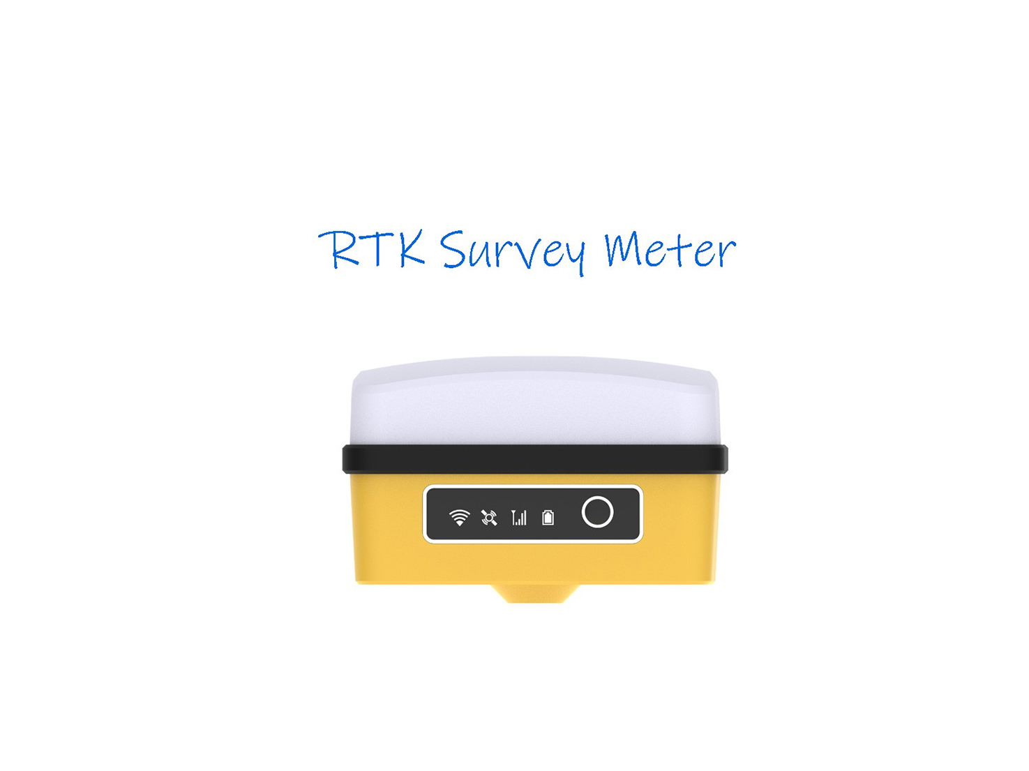
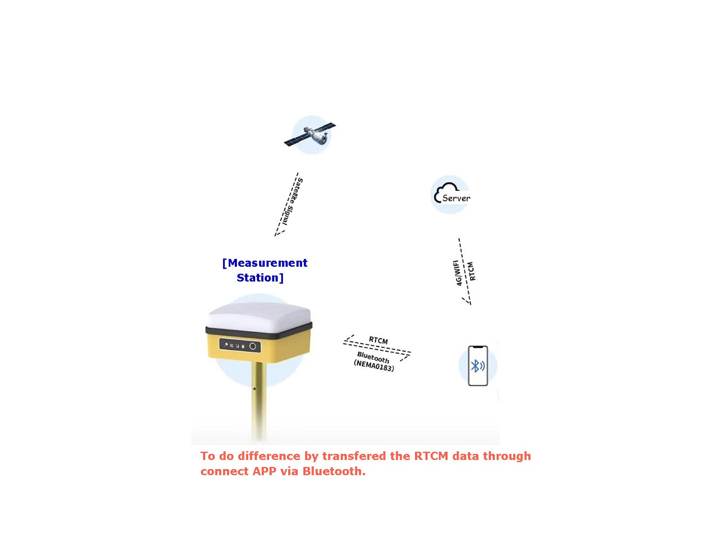
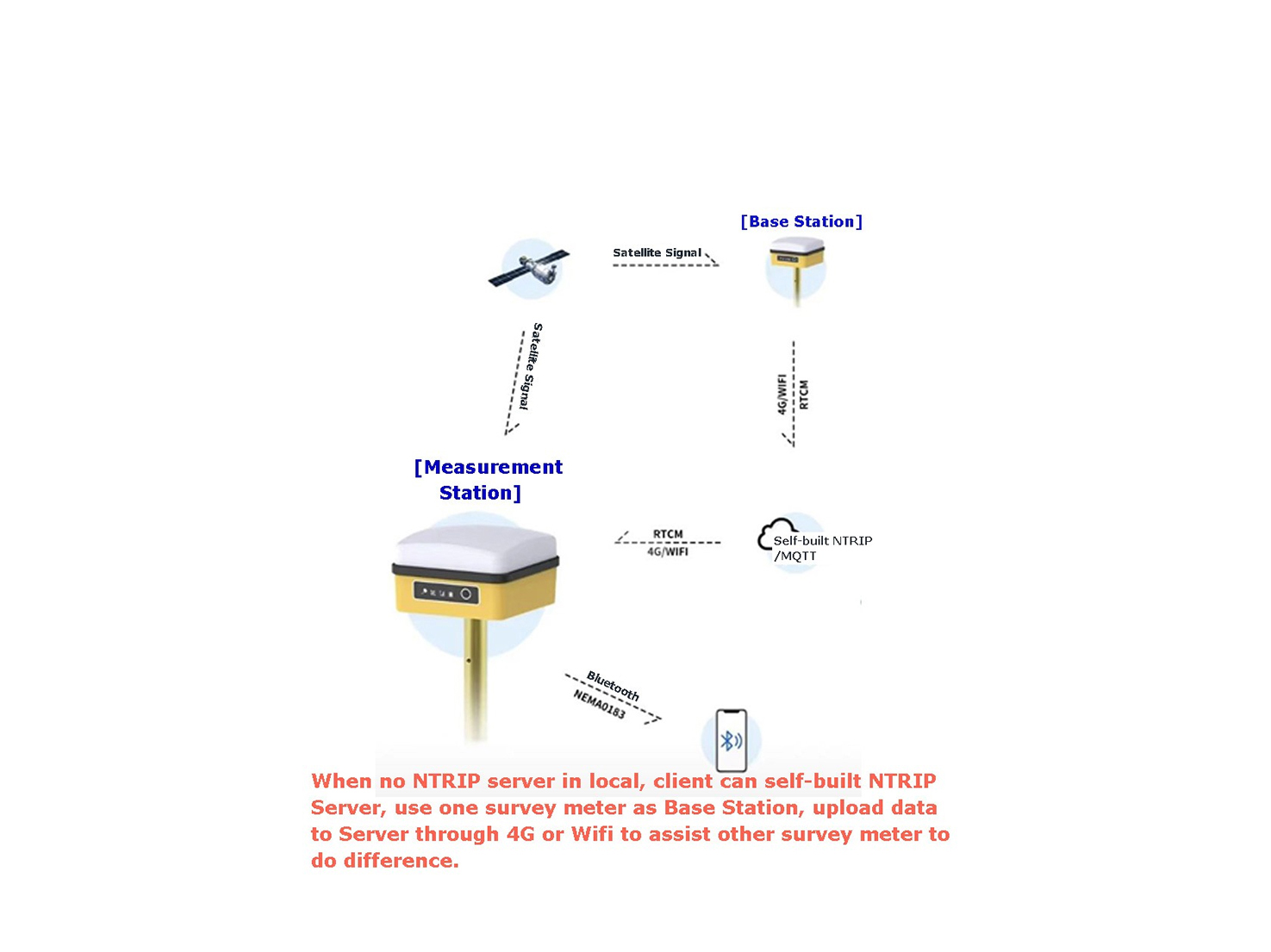
Contact Contact

Get quotation
Language
×
首页图标Home >  Product > Antenna+ > GNSS Receiver
GNSS Receiver

RTK Survey Meter For Intelligent Agriculture

*Full satellite full frequency RTK

*50-100HZ positioning frequency

*Inbuilt 4G, Wifi, Dual Bluetooth

*15hrs battery life, with type C 2hrs fast charging

*Anti-loss positioning function

Application: Can be widely used on UAV, lawnmower and other auto operation instruments. The system include a RTK base station and a RTK positioning module.

Leave a messageJT-9292 Long Distance UHF RFID Integrated Reader(Multi-tag) ContactRTK Survey Meter For Intelligent Agriculture

Overview

This Cube RTK  high-precision satellite locator (GNSS receiver) is a high-precision satellite positioning device using the latest technical solutions. It is small in size, light in weight, high in precision and full in function. It can be used as a reference station or a measurement station. It is a high-precision positioning device. The preferred device for measurement.


Cube RTK has built-in high-precision satellite positioning module with full-frequency point or four-system eight-frequency point, high-precision measurement satellite receiving antenna, IMU tilt measurement module, 4G CAT1 full Netcom communication module, Wi-Fi communication module, dual-mode Bluetooth 5.2 communication module , PD fast charging module, built-in large-capacity battery for up to 15 hours of battery life, support 4G&Bluetooth differential and upload RTCM data through 4G, WIF.

Key Features

• Two working modes

Users can choose one of two modes, base station mode and measuring station mode. In the measuring station mode, you can choose to open or close the inertial navigation tilt measurement function.


• Felexible Setting

Users can customize the enabled constellation, frequency point, positioning frequency, and minimum elevation angle.


• Multi communication method

Wireless communication, 4G, Wi-Fi, LORA, Bluetooth. Users can query the status of the data card, recharge, Wi-Fi hotspot settings, and LORA communication settings through the applet or APP.


• Tilt measure calibration

The antenna has tilt measure calibration function, which user just need to simple move the antenna rode, in few seconds the antenna can entry fixed station.

Specification

Satellite Positioning Parameter
Satellite BDS,GPS, GLONASS, Gallileo, QZSS
Frequency BDS B1l,B2l,B3l,B1C,B2a,B2b1
GPS L1 C/A, L1C1,L2P(Y),L2C,L5
GLONASS L1,L2
Gallileo E1, E5a, E5b
QZSS L1,L2, L5
Positioning accuracy RTK Plane: 0.8cm+1ppm, Elevation:1.5cm+1ppm
Tilt Calibration Accuracy: 2.0cm(within 30°), tilt measurement function is optional
Data format Input difference date format   RTCM3.3, Output position data format NMEA0183, 1HZ(Customizable)
Wireless technology Parameter
4G LTE-FDD:B1/B3/B5/B8
LTD-TDD: B34/B38/B39/B40/B41
Wi-Fi IEEE802.11b/g/n
Bluetooth BT 5.2 BR/EDR/BLE
General Specification
Dimension 104*104*65mm
Weight 450g
Bottom Thread 3/8 inch
Battery Capacity >= 6000mAh
Battery life 15 hours
Terminal Type C
SIM card Patch Card/Plug Card
TF card Optional 16-128GB

Protection

IP65

Applications

This RTK survey instrument can be widely used on UAV, lawnmower and other auto operation instruments

JT-9292 Long Distance UHF RFID Integrated Reader(Multi-tag)

Have questions?

VLG Technical Consultants are here to assist you!

JT-9292 Long Distance UHF RFID Integrated Reader(Multi-tag)+86 186 8871 1070

JT-9292 Long Distance UHF RFID Integrated Reader(Multi-tag)Sales@vlg-solution.com

Leave a message

Related Products

Leave a message

Have a question. Talk to our Sales, Engineering or CS Teams today.

Contact
SHENZHEN VLG WIRELESS TECHNOLOGY CO., LTD

You can also reach us on +86 186 8871 1070, or sales@vlg-tech.com. Our sales department will reply to you soon.

Leave a message

    This site is registered on wpml.org as a development site. Switch to a production site key to remove this banner.